
Did you know that I could once name and locate all of the countries in Africa? How many people can say that? (Well, you might be able to if you teach Geography, but even most social studies teachers don’t know them unless they end up teaching a geography class.) How did I do that? It was quite simple. I had a really good college professor that loved geography and made African geography interesting. One of the most helpful and yet simple activities we did in class was to color and label a map of Africa. Yes, we colored…in college…and it worked. I know that adult coloring is all the rage right now, but when I was in college most people would have looked down on a professor that resorted to coloring to teach a college class. I have a very distinct memory of myself sitting in class at Clemson University coloring maps and LOVING it! It seemed simple, but coloring maps appealed to various learning styles of the students in the classroom and enforced the content multiple ways.
So, what does that have to do with US History? Oftentimes, we talk about land acquisitions without ever showing students a map of the result of said acquisition. Yes, the Louisiana Purchase made a HUGE impact on the size and natural resources of the US; but you don’t really get an idea of just how huge it was until you show it on a map. Did you remember the size of the Louisiana Purchase from your high school classes? Probably not. But how many maps were you shown? How many did you color and label? Probably none.
You get my point. Give your students blank maps and have them color and label important historical events, acquisitions, or information. Don’t think you have time? Some maps will only take 5 minutes to complete. You can always set a time limit and whatever the students don’t finish in class must be completed for homework. Some maps, such as a map showing land acquisitions of the US, would serve as excellent end of course review material! See some examples of assignments below:
American Colonies Map – Use the map found here. (No longer available.) Have students create a map of the 13 colonies. Students must label each colony and color the three main colony divisions: northern, southern, and middle colonies (or mid-Atlantic). Students must also insert symbols for economic activities and religious groups. Students must create a legend to go with their map.
Civil War Map – Use the map found here and tell your students to create a map depicting Union and Confederacy states and capitals. You can also have students label Fort Sumter, important battles, or other items (the Mississippi River). Explain the anaconda plan and have students label elements of the plan on their map.
Western Trails Map – Use the map found here. Have students trace and label the route that they would take to go west. They must label cities in which they would start and finish. On the back, you can have students explain which route they chose and why.
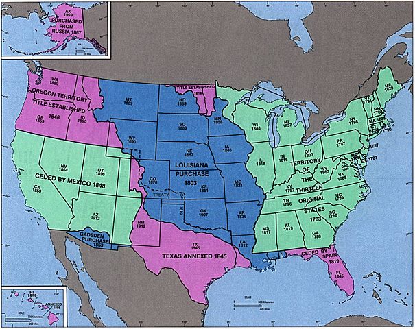
Land Acquisition Map – Use the map found here. Have students label and color all of the major US land acquisitions. Have them include the year we got each piece and who we got each piece from.
I actually found two products on Teachers Pay Teachers that give you almost all the maps you might want for US History. There are two different packages based on time period. Each is $9.95. Click here and here to learn more. If $20 seems a little steep to you, just Google a map you want and you should be able to pull it up. You may have to do a little copying, pasting, and resizing, but only once per map. Save it and use it again and again. The return on time invested will be worth it.